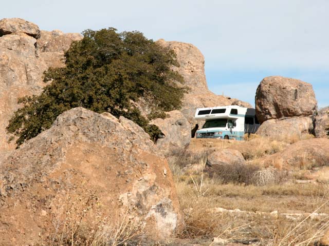
Even though it's roughly the size of New Zealand (113,000+ square miles), Labrador has only about 75 miles of paved roads. All the other roads (and there aren't many), including the main road through the interior, are gravel (and liberally "sprinkled" with many potholes, according to some Labradorians we talked with...we did not venture into the interior). There are fewer than 30,000 people in all of Labrador, with half of those folks living in the two biggest "cities". In fact, there are more caribou in Labrador than people. 750,000 of them. That's 25 caribou for every Labradorian.
A vast land, relatively few people, fewer roads. Mountains, rivers, lakes, waterfalls, immense expanses of forests, abundant wildlife.
Labrador is wilderness at its most wild.
Regretfully, we were able to explore only a very, very small corner of Labrador. We took the Labrador Coastal Drive from L'Anse au Clair to Red Bay, a distance of just about 60 miles. You can see on the map below just how tiny a bite of Labrador we were able to savor.
But it gives me great comfort to know such a wild place as Labrador still exists on this planet.


The Pinware River

Just us and the loons (no comments, please ;-D )
Okay, how about this for a book or movie plot: a British researcher, while reading old Basque documents in a library in Spain, makes a discovery that rewrites Canadian history.
Nah,I don't think so. It sounds too far-fetched, doesn't it? But as the saying goes, "Truth is stranger than fiction."
Our story begins with a British woman by the name of Selma Barkham. Selma immigrated to Canada in 1950 and married an architectural student who had an interest in Basque buildings. They moved to southern Europe where Selma spent a great deal of time in the libraries of Spain, pursuing her own interest in early Canadian history.
In 1972, she discovered a 16th century marine insurance policy that referenced several Canadian ports frequented by Basque cod fishermen.
The fact that Basque fishermen were in Canadian waters in the 1500s fishing for cod was actually not news. But the discovery of this very old insurance policy intrigued Selma Barkham. She began to search for any and all Basque documents that mentioned Canada.
Her relentless curiosity paid off, and taking information she had gathered from hundreds of 16th century documents (insurance policies, agreements between ship owners and outfitters, crew hiring agreements, provisioning lists, maps and sailing directions), Selma Barkham pieced together a previously unknown period of Canadian history: a major Basque whaling port on the south coast of Labrador! Historians agree that it was the first large scale industrial complex in the New World.
Rewriting Canadian history, indeed!
Why such major Basque whaling in Canada? Because whale oil was a highly valuable commodity in Europe. Primarily used for lamp fuel and lubrication, whale oil also was a basic component of paint, varnish and soap. The Basques had been hunting whales in their own waters since the 11th century, but by the 16th century, the number of whales in the Bay of Biscay had declined significantly. When those Basque cod fishermen mentioned earlier told their fellow Basque whalers about the large numbers of whales in the Strait of Belle Isle in southern Labrador...well, the rest is history. Previously unknown history.
Because of Selma Barkham's research, archaeologists have now unearthed the remains of 20 whaling stations in Red Bay. These stations included tryworks, where whale blubber was rendered into oil, and cooperages, where barrels to ship the whale oil back to Europe were assembled. In addition, underwater archaeologists have discovered four Basque galleons and several smaller whaling boats. Add in the thousands of artifacts that have been found both on land and in the water, and the discovery of 140 burials, and a very clear picture of 16th century Basque whaling in Canada emerges.
Red Bay is now a Canadian National Historic Site and has a superb interpretive center. The following is just a sample of what is on display.
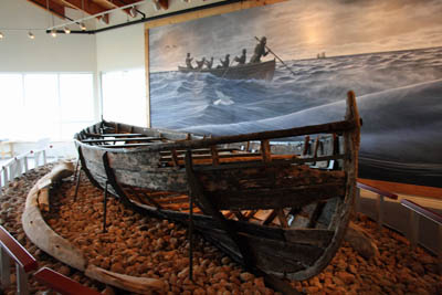
This boat, 25 feet in length, is called a whaling chalupa. Found pinned beneath the collapsed wreckage of one of the galleons, it was carefully excavated and is now on display in a climate-controlled room at the Red Bay interpretive center.

Several of the documents that Selma Barkham uncovered in Spain indicated that one of the Basque galleons, loaded with hundreds of barrels of whale oil, had sunk in the harbor at Red Bay during a storm in 1565. Armed with that knowledge, underwater archaeologists found and excavated what is believed to be the earliest shipwreck known in Canadian waters. In a remarkable state of preservation (due to the frigid waters), all of the pieces of the ship were meticulously recorded and then the majority of them were reburied in Red Bay so that the ship would be preserved for future research. The photo above is of a 1:20 scale model of the ship.
There were various small pieces of the four galleons that have been preserved and put on display. They offer a fascinating glimpse into 16th century navigation.

An astrolabe, a navigational aid that preceded the sextant.

Sandglasses were used on board ship to keep track of the passage of time and with a log reel (see below) to determine the ship's speed and distance traveled.

A log reel would have been used to coil and let out a line, with a piece of wood attached to the line. Used in conjunction with a sandglass, the log reel would determine the speed of the ship and the distance traveled in a given interval of time.
Many thanks to Selma Barkham and to Parks Canada for a fascinating history lesson!
--- Barbara (currently on Prince Edward Island)
Day 87
Total miles: 8,536
1 comment:
Barbara, your writing and Art's photography (and his writing, too)are wonderful. You two could be publishing literature for the museum, and for the provinces.
Also, thank you for including the charts from time to time to help your readership know where in the world you are. Although we should, not all of us have the detailed cartography of the Atlantic Provinces at our fingertips as we peruse your scintillating narration.
Post a Comment